Top 7 Yakutia (Sakha) Attractions You Must Visit

The Republic of Sakha (Yakutia) is the largest and coldest region of the Russian Federation.
Yakutia occupies a fifth of its territory: 2.5 thousand kilometers from north to south, 2 thousand kilometers from east to west, four climatic zones: taiga forests, tundra, forest-tundra, and the Arctic desert.
And another 4,000 kilometers of sea beaches, on which, of course, there are no tourists, these are the beaches of the Arctic Ocean 🙂
This is where the cold pole of the Northern Hemisphere is located – the region of the Earth with the lowest recorded temperature where people live. On the other hand, people are friendly and glad to meet guests.
Today, Yakutia is ready for the arrival of tourists: resort areas, ecological routes, ski resorts and, of course, unique natural attractions, waiting for curious tourists who want to conquer endless expanses of the Russian North.
Lena Pillars Nature Park
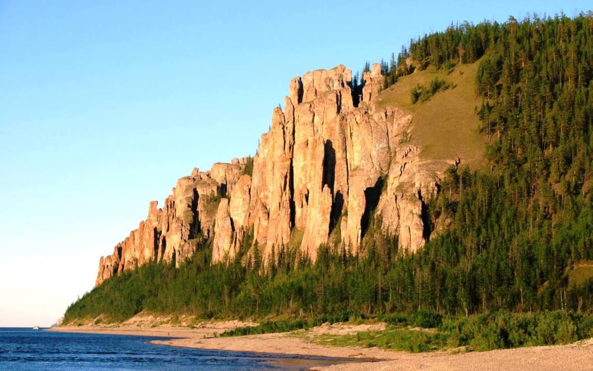
Lena Pillars is a geological formation located on the banks of the Lena River in Khangalassky Ulus, 104 kilometers from the city of Podolsk.
This natural formation is a complex of vertically stretched rocks that extend along the entire bank of a river. Between the villages of Tit-Ary and Petrovskoe Lena Pillars reach the highest density. The height of the rocks reaches 100 meters. It leaves a great impression!
It is known that the formation of rock began 560-540 million years ago, and the relief of the pillars acquired about 400 thousand years ago. The rifts and deep river valleys appeared due to the elevation of the Siberian continental plate, as a result, there was an activation of karst processes that gave rise to such original rock forms.
Learn 10 benefits of traveling the world
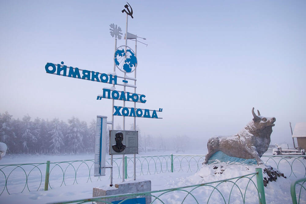
Verkhoyanie – the northern Pole of Cold
During winter, Yakutia is the kingdom of white snow and burning icy cold. The air temperature drops to record values: -60, -65 °C, and average annual temperature is everywhere below 0 ° C.
The region of the lowest temperatures is located in Central and Eastern Yakutia, and in the latter there is the Cold Pole of the Northern Hemisphere – Verkhoyansk city, where on January 15, 1885, the temperature was -67.8 ° C. The closest minimum air temperature (-67.7 ° C) was observed in the village of Oymyakon on February 6, 1933.
The climate in this area is subarctic, sharply continental. The average temperature is −38 ° C… −48 ° C in January, +15 ° C… + 17 ° C in July. Yearly rainfalls range from 150 mm to 300 mm.
The lowest air temperature (−67.8 ° C) outside of Antarctica was recorded in February 1892 on the territory of the ulus in the city of Verkhoyansk. The district has deposits of tin, antimony, gold, silver, tungsten, copper and other minerals.
Oymyakon is an informal Northern Pole of Cold. Regular meteorological observations are conducted not in the rural locality Oymyakon, but at the airport with the same name. This airport is located 40 km far from the rural locality Oymyakon and 2 km from the village Tomtor.
However, when they talk about the minimum temperature, the name of the locality is always used. Oymyakon is a rural locality (a selo) in the Oymyakon Ulus of Yakutia, on the left bank of the Indigirka river.
It is noted as the Pole of Cold of the Northern Hemisphere with a minimum temperature of -71.2 ° C in many encyclopedias. This was only the estimated temperature shown by the expedition of the academician Sergei Obruchev in 1926.
It has to be said that Oymyakon is the general name of the whole valley, where several rural localities are located. The absolute officially registered minimum temperature (-67.8 ° C) belongs to the Verkhoyansk city.
Learn about the best things to do in Belarus in winter
Tukulans — the Yakut deserts
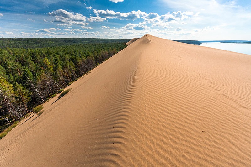
Of particular interest on the slopes of the Lena River valley are the huge arrays of waving sands – sand dunes, called Tuculans. Tukulan in Evenk language means sand.
The largest tukulan Saamys-Kumaga is located below the confluence of the Deering-Yuryakh stream. Sands reign here, forming a piece of real desert amidst green taiga. They are considered to be exotic of Yakut nature.
Tukulans differ from other deserts by the abundance of full-flowing lakes occupying blowing out basins, vegetation, and climatic conditions. The formation of deserts is not always associated with a hot and dry climate. Sometimes they are found in the northern territories, where it is cold in winter and it is quite hot and humid in summer.
Mir Kimberlite Pipe (Mirny Mine)
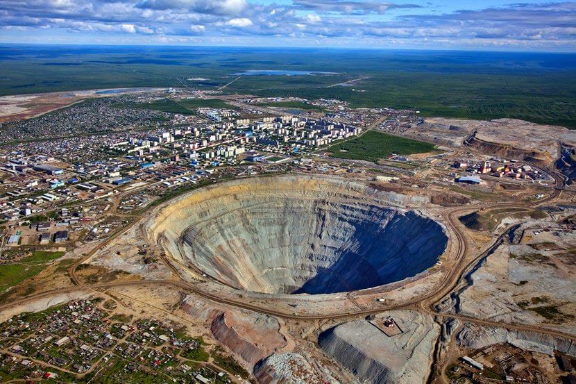
This is one of the world’s largest diamond mines. The kimberlite pipe Mir is located near the town of Mirny in Yakutia. Mir mine is not only the hallmark of the diamond capital of Yakutia but also one of the main attractions of the country.
The kimberlite tube, located in the west of Yakutia, is one of the deepest in the world. The depth is 525 meters, the outer diameter is 1200 meters with a bottom diameter of 300 meters.
Mine digging started in 1957, diamond mining was carried out for 44 years. In 2001, mining of diamondiferous kimberlite ore was stopped here and the mine has remained mothballed ever since. There is an observation deck on the territory of the mine for tourists from where such a view opens, it captures the spirit!
Check my list of top 15 Europe winter destinations
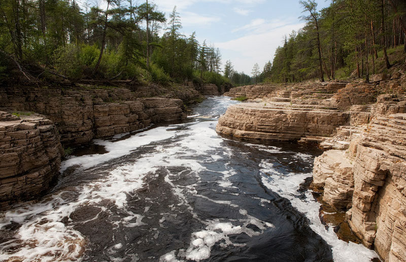
Kurulur Waterfall
Kurulur waterfalls are located on the Menda river in the Khangalassky district of Yakutia. They are situated on the right bank of the river Lena in the taiga zone, 110 kilometers along the road from Yakutsk and 10 km from the Bulus glacier. That is why Yakutia tour operators combine these directions in one tour.
Sacred Kysilyah Mountain
The true masterpiece of the mountain part of Yakutia is the Kysilyah mountain. It is located in the Verkhoyansk district on the watershed of Yana and Adycha rivers in the spurs of the Kisilyakhsky ridge, part of the mountain system of the Chersky ridge.
The height of the mountain Kysilyah is 1070 meters above sea level, the length is about 25 kilometers. It is all studded with column-shaped rocks, the average height of which is 25 to 30 meters.
Kysilyah (Stone People) is a sacred mountain for Yakuts, whose age, according to geologists, reaches 60 million years. Mount Kysilyah is a unique nature creation, one of the wonders and truly natural shrine of Yakuts. There is no other mountain in Yakutia so revered and protected.
This is one of its most picturesque places in Siberia. The majestic cliffs form delightful compositions resembling the shapes of people and animals in their outlines. Here is the Rock of Love, and here are the Rocks of the continuation of life and the Trinity Rock. You can also find pillars of fantastic forms in other areas of Yakutia mountains.
There is a belief that Yakuts and Evens, who lived in the vicinity of the mountain in antiquity, when trouble came, always turned to the higher forces through Kysilyah mountain. And only shamans were allowed to climb the sacred mountain.
According to Yakut belief, the magical powers of the Upper Gods — Aar Aiyy — are crystallized in them. It is believed that the Gates of Angels are located on this mountain, which leads to the abode of the Upper Deities. Here, each Rock embodies its own Deity, each of which carries its own mission.
Bioenergetics and psychics, who happened to be on a pilgrimage to Kysilyah, call it the “North Shambhala” and “the energy center of the planet”. By mystery and uniqueness, Kysilyah is placed on a par with Easter Island, Stonehenge! It has long acquired ritual significance and turned into a kind of sacred sites.
Labynkyr Lake
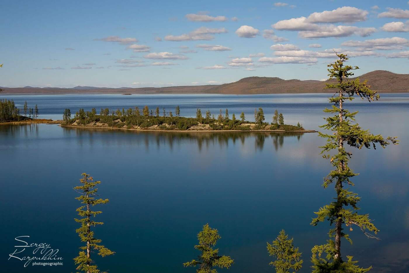
Labynkyr Lake is one of the most beautiful parts of the Oymyakonsky district of Sakha Republic. The lowest air temperature is 70 ° С, the “Pole of Cold” values are set in this area. The fairy tales and legends of the lake attract travelers to the search for traces of “northern dinosaurs”.
The lake is located at the altitude of 1020 m above sea level, whose length is equal to 14.3 km and a width of about 14 km. The maximum width is 4.14 km. The average depth of the lake is up to 52.6 m. At the same time, there is an anomalous crack at the bottom of the lake, which increases the lake depth to 75-80 m.
Why You Should Visit Yakutia
They say that only those who have visited Siberia, get a real picture of Russia.
Well, Siberia is large, so it’s up to you to choose your travel destination. But we will say: a day’s journey through the Oymyakon Valley can turn your view of the world.
More precisely, one of the three worlds, as the Yakuts believe – Medium world. The one between the Upper and Lower worlds.
Check my travel planner to travel the world cheaper and better